Monday, June 24, 2019

Day 5 - pretty ones (Judy)


Day 5 - That sky! (Judy)


Day 5 — a chase of a day!

About 900 km on a real chase through Oklahoma into Texas. We started with our analysis on paper and discussed target areas in teams, then loaded into vehicles, accepting the offer of a tour through the Accuweather facilities with The former graduate of our course a few years back. The office was right downtown, and traffic was very light on the Sunday morning. 
The operational group was up and running in this 24/7 operation... impressive tracking of weather, responsiveness to a wide range of agricultural and industry clients, EMO officials, and event-planners, in the USA and internationally. They run sectoral, national, and very issue- or client-tailored datasets, and report as required by each. They were all articulate and enjoyed their work at computers, each linked to many monitors for different, concurrent displays of many product runs. They also track Canadian weather, and one of our instructors relayed the while the US has National weather Storm Prediction Center that issues all weather watches and localized warnings are outlined in conjunction with county or local officials, Canada has regional offices that issue both watches and warnings directly for very large regions (e.g., prairie central region includes Alberta, Saskatchewan, and Manitoba and extends to the the Territories, the Arctic, and into Northwest Ontario. After students asked weather and career-related questions we filed out and presented our Miller analyses outside in the shade. In good group presentations of our charts, all three teams identified two regions, one in mid or west Oklahoma and another in the area where Nebraska, Iowa, Kansas and Missouri meet up. After the previous day (or really more), the latter was going to be tough to get discrete cells and was already in the morning involved in new thunderstorms in the morning, so we'd miss it by the time we got there. To the delight of those wanting to put another state on the list, we were heading west and south, likely into Texas depending of how things turned out with weather during the day.
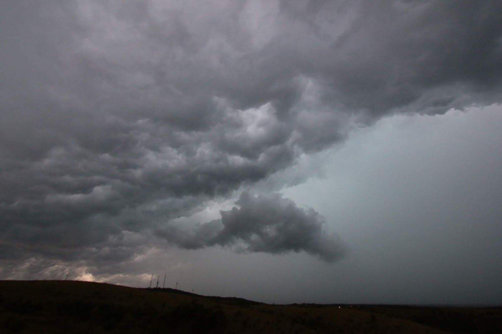
We headed south on I-35 watching radar carefully as we threaded between cells on the radar display, knowing there were prospects of heavy rain (realized) with possible hail. After stopping in the burning sunshine for gas and a quick lunch (fast-food outlets were mostly slow), and watching at least one chaser vehicle race out southbound ahead if us, we got back on the highway and headed south once more. Traffic was very slow on a 30 mile stretch as there was an accident in the midst of a construction zone that was down to single lane flow. The initial plan at 5pm was to go to Ardmore and turn east to intercept storms coming toward us in that location. But our stop (and photos) at the junction showed a nice wall cloud and lightning (another “repeater”) to the west and more than one cell that looked promising, so we drove uphill in their direction. We got to a turnoff into a scenic overlook about halfway to Wilson, where there were already tripods doing time-lapse imaging. We saw heavy rain and hail approach fast from the western valley we looked over, and peered into a “whale's mouth” of sunshine over the hill to the southwest. As rain got heavier, we decamped and headed further west, now going in curved roads up then downward. We turned south at Wilson onto road 76 watching the sky and radar displays trying to fine a good view to the west without trees along the road, and not get trapped in a bend of the Red River of the South without a backdoor exit if the weather got too rough with hail or the hoped-for tornado. There were two cells coming one after the other, both topping about 45000ft. We stopped on the roadside in sunshine again, with heavy, green-grey clouds to the west, and watched the lowering cloud deck, and dark layers in the anvil. The condensation in the updraft was tantalizingly dark and beautiful above the turquoise blue-green, eerie and somewhat threatening sky. I looked for rotation but didn't see any on the underside of the cloud deck. We all felt the wind shift from the warm updrafts to cold downdrafts, sometimes for very brief periods, other times for longer times. The roadside setting in tall grass and wildflowers was perfect for watching the lightning as the rain approached and the first heavy drops fell. Knowing we needed to get out from under with that safe exit to the south (the alternative being to core punch straight west into the oncoming storm with a mandatory turn to the north, also in the storm, and stay in Oklahoma). I remember thinking there were so many changes from brilliant sunshine to stormy with pouring rain in one day. Loading once more into the chase vehicles, I thought with no small regret, that this may very likely have been our last chance to see a tornado forming, and it turned out that way, alas. 
We turned west on 32 through Courtney in heavy rain, then south over the bridge, crossing the very red, Red River laden local earth, into Texas. It continued raining heavily through our pitstop in St Jo, then lightened up by Muenster (unfortunately without a stop for the poppyseed strudel advertised on a billboard along the highway). It was already getting late in the daylight and any further storms were further west or south, so we got back to the interstate and drove back to Ardmore for cajun-style dinner at Two Frogs, complete with a collection of fancy electric and acoustic guitars autographed to the owners by famous crooners or rockers, accompanied by B&W photos of some same and others including images of young Dylan, Jagger, Cooper, etc. We had enjoyed the chasing on our last chase day before the long drive home, and were enjoying one another’s company. We stopped for a group photo under the “Two Frogs” neon behind the live-band stage in the restaurant, loaded into the vans, and drove north to overnight again in Oklahoma City. 
As I now do understand, tornadoes are truly rare events in fairly commonplace severe thunderstorms, and the instructors leading our chase had given us the best opportunities, right in the inflow notch of more than a few supercells. All in all, we'd actively chased in seven states (SD, NE, IO, CO, KS, OK, and TX). The weather pattern with a south-lying jet stream, means that severe weather and chasing were further south this year than in previous course runs. Of nine or ten courses that have run so far, only three saw tornadoes (one saw one and two saw multiples, three or four). I'd bet that more than one member of this year's course will chase again, whether or not they become meteorologists. An interesting time to travel trying to find really bad weather that typical vacationers on holiday would try to avoid! 

Looking back, only a few days has brought a significant experience, weather-wise intellectually, in real-time learning, and personal, to each of us and to the group as a whole, as we're becoming friends who could really work together and continue enjoying one another’s company. An A+ and vote of confidence with thanks, to everyone! Something tells me that the Canadian weather forecasters (and the public) are going to gain at least a few new colleagues from among the class, and judging by the preparations, thinking, and presentations this week, they will be excellent! Judy Anderson

Sunday, June 23, 2019

Day 4 - still Kansas, Dorothy

Travelled about 600 km from Garden City KS to Wichita KS - the long way!
After analysis of the models projected for 00Z (printed before the current data were available, the surface analysis suggested somewhat different regions of tornado potential. So instead of heading to areas like the west Texas panhandle or eastern Oklahoma, we were going to intercept potential initiation in north-central Kansas; we were going to have a short-distance day. We went east to Hutchinson, where temperature was 34C with a dew point of 24C. It felt like you could melt on that sidewalk! A late lunch was planned to give us flexibility about the need to find  dinner when storms would be picking up. On radar there was very little except a north-south line forming with slightly higher but still low-level water density in a fuzz of green echoes. A BBQ lunch of very tasty, crisp-on-the-outside ribs, topped off with a well-shared sour cherry cobbler was delicious as well as substantial. 
We drove north to I-135 and up toward Salina noticing growing towers of altocumulus on the west and thickening haze; on radar now, there was a small, interesting cell starting to hint at rotation amidst other developing storms. Even while finding a useful road to avoid the airport and a National Guard artillery range, the cell of interest faded almost completely and two to the west were merging along the outflows from other cells. It was neat to see how one storm had an elliptical shape that was flattened on the southern aspect, which we thought was at the gradient in the charts of both CAPE and helicity, just outside the CAP. So we drove a bit west to a gas station parking area, a took a bit of time-lapse to follow the rotation of the circumference of a wall cloud, low beneath the LCL. We moved about 1/2 km to a vista without wires or trees in the way of a view, and the colour of the low sky was a greenish-purple-grey. There was lightning close by, and a lowering part of the wall when suddenly lightning struck just down the road to the south, maybe a kilometre away, almost immediately followed by loud thunder. A “mite” too dangerous for comfort! We pulled up tripods fast, and high-tailed it out of there onto a different road, driving only a few kilometres to another roadside, donning rain jackets, to watch the same wall cloud continue rotating. But it was rising and needed to cycle back (or not) so we loaded up again to intercept the next cell. Now we were going down country roads with nice residential properties but trees along the roadside and back along property lines and streams, so visibility wasn't that great. At one point there were two lighter grey projections from a very dark cloud base that were tantalizingly tornado-like, but alas were not. Then we headed to the southeast slightly, where it seemed possible to see most daylight illuminating the low-level sky, and the three experts conferred on our next destination. Then we drove south to intercept a new storm developing west of Lindsborg, but it was reported to be dumping softball-sized hail. We filled up with gas and snacks, ice-cream sandwiches, and oreo cookies. Then not seeing anywhere with tornado potential, it was decided we should have a bit of a hail experience. This time we got into a downpour and the hail started just as visibility dropped seriously; it was no time to risk the hit of baseballs, so we backtracked and waited under the canopy of our earlier gas station, for the heaviest rain to pass. By then the system seemed to have degraded, and although there were a lot of high echoes on radar, none had particular prospects for developing a tornado. 
On the way south on I-135 into Wichita, there was quite a display of lightning to the east and then to the south as we drove between and sometimes through storm cells dumping heavy rain. One bolt came out of a dark sky of heavy cloud down to the ground in a wide spike, then seemed to go back up, only to return to the ground again and again, along the same track. It essentially pulsed up and down in brilliant staccato. With all the rain and Saturday evening distractions, not to mention lightning and wind gusts, drivers were again showing their mettle. 
Arriving at the hotel in the city centre, the rain and thunder really let loose! We spent an hour just outside the doors, under the canopy, enjoying the downbursts of pouring rain, waves of it in strong wind. Some were catching reflections of the plaza, complete with  lightning bolts down into the shopping area just across the wide road. After checking in, everyone went out for a late dinner at a taproom and R&R of discussions, weather-related and not; the class is now a group! One of the students of a former storm-chase course joined the group, and updated the instructors. She'd interviewed with Accuweather, and they'd been surprised at her level of knowledge and storm-chase experience; she's one of the only Canadians to be working there! Kudos to GEOG 4670! I'd echo that the course has shown us all a part of life that we were curious, fascinated or excited to learn for one reason or another, and the best part is that we can learn enough to make a reasonable prediction and then keep learning along the way by checking the surface and upper air charts, models, radar, and mesoscale discussions. It's a whole different set of parameters to consider in life, with a vocabulary new to many of us. And that brings future prospects of new analogies and puns, as well as a bigger-picture view of weather itself, and a much finer-scale perspective on severe weather. I will be interested to see how I approach thinking about severe winter weather, later in the year, too, as there must be some prognostic similarities across the seasons. Gives food for thought on how meteorologists must be hard-pressed to update models in a time of very southerly jet-stream flows as we're seeing this year, together with climate changes and ongoing severe weather this far south. No wonder, models are challenged.
It was a late night ended in some fun as we overnighted in Wichita. Judy Anderson

Saturday, June 22, 2019

Lightning in the storm, day 3 (Judy)


Day 3 UM chase to the west

Travelled over 1000 km from Lincoln NE to Garden City KS.
Miller analysis by the three chase teams was delivered to a charming family (2 truckers, a beribboned, curious and smart 4-year old daughter fascinated by the weather channel, and her purse-sized poodle with bows to match hers) and the class, the weather briefing was detailed. It was a tough decision, even for the instructors, with tons of instability that provided  many locations with strong potential for storms. However, in the end, the decision was to head west into eastern Colorado where storms might be more discrete cells and the cap on the eastern side could lift later in the day. As we headed west from rainy Lincoln (having been under big thunderstorms and very strong wind gusts overnight) to McCook area, the sky cleared then gave us a beautiful display of wave-patterned cirrus over lush green fields and forests remnant between them. As cirrus thickened into fine-grained high condensation and lower cumulus clouds), we left the flooded areas of eastern Nebraska  and the temperatures and dew points shifted from warm and humid to more pleasant. After a good lunch in sunny, warm Oberlin, KS, our path took us south to the I-70, then west to Seibert, CO. There was a good cell building high to 45000ft, that was generating reports of possible tornadoes and land spouts from chasers and police, along with hail, mesocyclone status from SPC, and a severe thunderstorm watch then warning box. That storm was heading almost straight eastward or slightly east northeast, and then turned to the right and started to show a “throat” of inflow and rotation in the doppler radar. At first it seemed a gradual mover, but as we went south from Seibert toward Kit Carson, it (and maybe me, as well) caught the speed of excitement. We stopped first on a side road heading briefly west (the first jog in highway/road 59) to feel in warm inflow and how strong the winds were carrying it toward the cell. The sky was darkening and the anvil spreading very wide. (I made the mistake of finding ‘a spot’) in an old homestead for photo and pee break, jogged back to the vehicle, realized I'd dropped the cell phone. So I jogged back in, found it and jogged back, trying not to delay the one remaining chase vehicle too much. The error was running through a ridiculous amount of speargrass, so socks and shoes put me on pins and needles, literally.) 
From there we zigzagged on gravel and dusty dirt roads, heading west then south, and west again through dry pasture and drier sagebrush-filled pasture. On the radar screen overlain with chaser markers, the highway from Limon to Aroya was like a string of beads... lots of chaser interest in this cell! We went south to Kit Carson then to Eads to fill up vans and snack quotas. The storm was passing but in the distance we could see daylight and lots of dust picked up by outflow winds, over to the east. We were waiting for a new cell to the north to develop and the plan was to intercept it on the south side as it travelled to the east southeast. Heading then toward Kit Carson in view of a rainbow to the east, we stopped briefly on a farm road in tall grass, with wildflowers, badger holes, and a snake sighting, to photograph the buildups and prominent hail shaft in the orangey light from the low sun angle. From there we went to Kit Carson and then directly east. Soon the buildups were tall and nasty looking, layers of grey-blue to purple with a white lip on the back end of the anvil directly overhead. It was very dark, threateningly so, directly ahead and just behind that anvil edge was a clear, very beautiful blue. 
Soon we started to see hail on the roadside, then with car lights on, there was a string of vehicles on a road covered in nickel or larger hail. Lightning enhanced the feeling of urgency and ‘white-knuckled’ driving (thank you to those careful drivers!), and hail got heavier and more coarse. Corn crops were broken, smashed and showed stripes of hail between the tattered rows. There was way less, if any thunder, compared to the storm on day one, but lots and lots of cloud-to-cloud and C-G lightning and we took videos of the road and the lightning strikes while driving only about 30kmh... an estimated 2/3 of that 90-mile drive was on a hail-covered road with drifts of hail, power outages, and tree damage. Cows in the fields seemed dazed in the whiteness that spread densely under increasing illuminated clouds and dramatic snakes of lightning strikes. The danger of hail and the potential for hidden tornadoes really struck home and we were excited, and quiet in the tension of driving through the back side of the storm core... when we reached Sharon Springs, we stopped for two minutes to feel the cool air and stretch, switch-out the tired drivers (well done, people) and assess the timeline. It hadn't been possible to go south to get out from under that slow-moving cell, and our slow progress at nearly the same speed had kept us under the back side of the storm for that whole distance. 
Alas, dinner was impossible as we had more than a few hours to go before the motel in Garden City. So with lightning continuing to the east behind (north) of us, we discussed the drama and reviewed pictures, posted some, and talked about the models showing that our next day could have a lot of action in the atmosphere. 
It seems that every storm has a uniques character and depending on conditions, only some of which are understood or charted, and one's exact position and attention, that observations are always informative whatever is happening. Each of us had their own pattern of responses to conditions that really were dramatic and mostly not in our previous experience. Fascinating to see how we all had appreciated the drivers' care and sent concern to our accompanying film maker, driving alone into unexpected conditions, connected to one vehicle by walkie-talkie that relayed information in the light show... it was spectacularly beautiful in an eerie dark, threatening way... the glow of lightning illuminating the inner structures of that mesoscale storm of pinky oranges. The storm we'd left earlier, that gave serious rain and wind overnight in Lincoln and headed east, gave a near-record number of wind-damage reports in a wide swath all the way to the eastern coast... people there, sure don't need rain!  Judy Anderson

Friday, June 21, 2019

Day 2 into Iowa


Day 2, 682 km through Iowa, into Nebraska.
The day started with analysis of maps from weather models, with students split into 3 chase groups. We studied maps and compiled Miller analysis charts for an hour then each group presented the analysis with target areas of choice, two of them, where we were interested in chasing. All three groups were in pretty good agreement about the areas, and we started off toward the east of Northern Nebraska, near the border with Iowa. After the gas/lunch stop along the highway, we headed east toward an possible intercept area. There were a few very discrete cells with high moisture content and high tops, moving northwest to southeast and we were aiming to see storms developing as, hopefully, the cap lifted, because the CAPE and shear were high and the existing cells were energetic. Just north of us as we got to an area near Westpoint, and pulled off on a gravel road between a corn field (~knee high) and a field of 6” soybean plants. The local traffic was interested in why we were stopped and hoped there were no storms as they've had enough, but they wished us luck. We watched altocumulus castellanus clouds forming and trying to grow out of scattered small cumulus visible on the satellite loop, for an hour or so in growing heat. It was good practice for time-lapse imaging on cell phones and cameras. The buildups kept getting sheared off early, although they looked like they ‘wanted to’. So we drove to Westpoint for ice-cream and to wait for the cap to move off, temps to build and let the instability grow. 

The DQ visit was full of fruitful blizzards (and welcome AC) with good conversations with some locals about “good storms” for us being “bad weather” for farms and folks in the area. We adjourned to the local park and waited in the shade, on swings, and on walkabouts with a close eye on developments in the sky. A new-found four leaf clover in hand, we took a group photo clustered around the tank on display, and headed back to the northwest a short distance to rolling countryside and stopped to watch the sky. Now clouds were building much higher and after seeing some really good castellanus formations merging we loaded in vans. Shortly up 5he hill, we saw a pileus formation on top of one tower, and the a second layer on top of that. A small bit of ‘cauliflower’ poked through the first pileus layer, and as a third layer formed further up, the buildup poked through the second pileus layer and spread back a bit downwind. This was the area where a small wall cloud seemed visible in the distance  under the base of far-away cloud, earlier when we were watching from lower in the pasture area. The instability was poking through the cap! So we barrelled back to the highway and crossed over the very full Missouri river into eastern Iowa, found a turnoff away from wires and set up gain along the edge of the road and in a nearby field. 
On the short drive, the radar had showed a bit of a hook echo marking rotation, and there was a hail report. The storm was now definitely a STORM, and the anvil was growing back to the northwest overhead. Between crepuscular rays to the north the south edge of the anvil, there was a rain shaft with foot developing, and the in the lower, dark area under the storm, a wall cloud developed and dark flanges of it definitely showed rotation. There were oh so many projections down, around its circumference but no funnel... inflow was so prominent and a really prominent beaver tail-like structure projecting under the storm from the south feeding into it from beneath. The storm was cycling between growing stronger and weakening as the rotation appeared the wear out and the wall cloud disappeared, so it wasn't able to really sustain the energy to make a tornado. As the wind outflow came past us and rain was starting, we loaded tripods, cameras, and ourselves back into vehicles, and shifted position to the south and east. We'd so wanted to see a funnel, but alas, it was not to happen!

Again we found a turnoff between quiet corn fields, and set up to watch another newer cell build higher and higher in the sinking sunlight. The colours were beautiful inside the storm, seen between lower-level dark cloud n the shadow of the anvil. With lovely crepuscular rays, the opposite side of the sky, just on the south edge of the storm showed anti-crepuscular rays just beside the rain shaft. Each new ‘generation’ of ‘cauliflowers’ building in the new cell was first white-white, then a rich shade of pale buttery yellow, then golden, as it rose rapidly (easily seen, even without aid of time-lapse). Again, there were new storms building to the northwest, anvils showing pinkish in the distance, but although there was an area of “disks” under the cell we were under with some slight rotation, the storm wasn't building high enough. The mosquitoes started to annoy as we loaded up again, and headed for dinner at the Icehouse sports grill in Omaha. It was great to eat on the patio as it got dark and the draft was tasty, mixed in with delicious chatter about the chase and storm-cloud observations. People posted time-lapse videos and tweated, and we headed out. It was 12:30 when we got to the motel for O/N in Lincoln Nebraska. Overnight  there was really severe wind in the major thunderstorms that poured on Lincoln and surrounds that night.  A great day of learning with real-time observational input — living the data!! Judy Anderson 

Thursday, June 20, 2019

day one, UM chase

1218 km day 1 of chase. We saw and tracked a supercell into the area of interest, south of Chamberlain SD and chased it for almost 5 hours. On the way a lot of lush land from lots of rain early in spring, beautiful hills and valleys in foothill-type country. Were on and off in heavy rain and had to protect cameras. The storms were not supposed to be severe, but we were going there to get the first taste of a chase, and have opportunity for good photography with a lower sun angle toward evening as there was clearing to the west of the storms. But later there were warnings issued and even report of a funnel. The radar showed very heavy precip consistent with large hail, but there was very little if any, on us. We had a beautiful view of sunlight through the inflow right beside the rain foot, and amazing swirls of inflow curving upward and into the cell. Moved at least three time to find better, safer views of the inflow throat, at one point passing a house completely engulfed in flames (apparently to remove a derelict building). Shot some video and stills in HDR of that cell and also one further south that was building and had a neat anvil spreading out but the TCU top was already overshooting the anvil. A time lapse of part of the back side of our main cell, still building on the back while dying out in the back. That was going on while a rainbow was arching up in the dark cloud, just at the point of a shaft of sunlight. Although we were surprised it was almost 8pm in the very long day, hunger and some rest, especially for the drivers. Reluctantly on my part, we left the view of towering storm clouds in growing sunset colours, to head for our destination for the night. We ate late at ~10:15, in Platte, SD, at the Yellow Rose Arena and Lounge/Restaurant, where the ceiling decor was a mixture of donated cowboy hats and women's apparel (bras) hung from the open rafters, in amongst the antlers and strings of lights. Then after a tour of the owner's concrete tornado shelter in the back, we climbed into vans and drove back to the highway. Landed at 12:30 am in the motel to O/N in Mitchell SD.

We all learned a LOT, watching together and pointing out observations of cloud formations to one another, from right underneath the cell we had targeted from mid-afternoon. It seemed the perfect combination of such knowledgeable instructors and SO much convection and dynamic change to watch in the environs, moving second by second, at each of our stopping points. I loved seeing that updraft with so much sunlight on it from behind, right beside the massive, dark rain foot. Oh, how I wanted to stay at each spot and see the next stage, which it was, just to watch although getting soaked was not a pleasant option. In the chase vehicles, the live screen in the back connected to the computer in use in the front seat was showing location of our chase together with radar and satellite looping images. We could watch the minute-by-minute changes in the cells as the developed from tiny spots on the radar into storms and supercells, moving in this case, very slowly from west northwest to east southeast. I was in the back seat of chase #1, and just seeing how the mouse moved in different screens, and us watching his little movements, showed a bit of what caught his interest at various times.  Judy Anderson

Friday, June 14, 2019

Forecast produced Friday June 14, 2019

Since the last forecast I posted, the GFS got retired and the GFSV3 became the operational GFS.  I don't see much difference in the way of how things on the large scale are handled, so I will take the new GFS at the same value that I took the old one.  I'm doing these forecasts from the 12Z model runs, except the Euro which comes out later so I'm using the 00Z run.

June 17 (84)
NAM: Eastern NM/CO
GFS: Eastern NM/CO
ECMWF: Eastern NM/CO
GDPS: SE CO

June 18 (108)

GFS: Western KS
ECMWF: Eastern MT to the TX panhandle
GDPS: Western OK/SW KS


June 19 (132)
GFS: Central SD/NE
ECMWF: Central Dakotas to central OK
GDPS: KS to southern SD


June 20 (156)
GFS: Eastern KS, maybe?
ECMWF: Southern SD or NE
GDPS: NE KS to SE ND


June 21 (180)
GFS: SW SD to south-central KS
ECMWF: Central NE
GDPS: Southern MN/northern IA


June 22 (204)
GFS: Eastern NE to eastern CO
ECMWF: Southern NE/northern KS or eastern CO
GDPS: Central OK, eastern KS, eastern NE, SE SD


June 23 (228)
GFS: Central NE
ECMWF: NE CO
GDPS: SE KS


June 24 (252)
GFS: KS or eastern CO

What this is telling me, though, is that we will have plenty of storms to see.  Moisture hasn't been a problem at all this year, and this time of year it's unlikely moisture would be a problem.  Aside from some local flooding, that is.  As well, though, the models seem to want to put a good strong belt of 500 mb winds overtop that moisture for most of the week, so the finer details should sort themselves out. But when I'm seeing consistent 40 to 50 knots forecast at 500 mb with instability in place, I'm thinking really good supercells.  The photogenic kind. And as well that tells me there is a good chance we'll be staying out later one night (or more) for lightning photography.

For some context, this time of year you need 25+ knots at 500 mb to see decent storms; the high terrain of Colorado and Wyoming can do some pretty magical things with storm structure with just marginal flow, and it appears the flow will be better than marginal.

The locations I mentioned above are what the different models showed as the *best* areas for that day; quite a few of those days, too, had a lot of good areas.  Driving will be kept to a minimum, as we can only do so much; as such, some days we may not be able to go after the best area simply because of logistics.

The first day will most likely be a travel day, and a long one at that.  If we leave Monday, it looks highly likely we'll be playing in Kansas on Tuesday.  That being the case, I'd want to get into Nebraska somewhere--Kearney, for example.  That's nearly a 12-hour drive, but it would leave us about 4 hours away from the theoretical target area.  that would be ideal logistically, but a bit of a long travel day.

We will be letting you know, likely by tomorrow, if we're leaving for sure on Monday.


Wednesday, June 12, 2019

It begins: the pre-chase forecasting

I won't go into as much detail as I have in previous years, but suffice to say that I've been looking at the models and how they've been trending and they're looking a) quite good for our chase, with abundant moisture and shear likely in place for at least a few of the days, and b) different every run with respect to the details.

If you really want to see what model spread looks like, I would say have a look at the 500 mb spaghetti plot from the GEFS (a GFS ensemble), and by usually about day 6 (144 hours), it really does look like spaghetti. (Time-sensitive link).

But here goes.  I'll give the most ideal location(s) where chasing would be good based on that day, given the model stated is right at that time.  I'll start on June 17 and go to June 27, although we definitely won't be chasing during the entire window.

June 17 (144)
GFS: Southern OK (we ain't getting there)
GFSFV3: N TX to SW KS
GDPS: SD

June 18 (168)
GFS: Eastern Dakotas or OK/KS
GFSFV3: OK/KS
GDPS: ND/MN

June 19 (192)
GFS: NE, KS, OK
GFSFV3: NE/SD
GDPS: The Great Lakes somewhere?

June 20 (216)
GFS: IA/MN/WI
GFSFV3: SD/IA
GDPS: AB/SK marginal

June 21 (240)
GFS: Western Dakotas
GFSFV3: MN/WI
GDPS: IA

June 22 (264)
GFS: WI/NW ON
GFSFV3: OK or maybe MT

June 23 (288)
GFS: KS/NE
GFSFV3: NE

June 24 (312)
GFS: SD, NE, KS
GFSFV3: MT/SK or NE

June 25 (336)
GFS: WI
GFSFV3: ND/MB

June 26 (360)
GFS: KS or western MT
GFSFV3: NE/SD

June 27 (384)
GFS: Southern SK
GFSFV3: KS/MO

So as you can see, it's certainly not a done deal as to where we'll be or even when we'll be leaving.

I'll post updates over the next week here.