Column 16: thunderstorms, part 2
Forecasting severe thunderstorms is one of the most challenging tasks in meteorology. You have to assess a lot of things and make decisions that can have a rather large impact on people's lives.
Whenever I forecast anything, be it winter storms, fog, or summer severe weather, the basic routine is always the same--analysis, diagnosis, prognosis. If you know me, you know that this has been my mantra for a few years, and will likely be so for a long time to come.
What do these words mean? It's easy. Analysis--what's happening. Diagnosis--why it's happening. Prognosis--based on that, what's going to happen.
Now in addition to my main mantra, I'm a proponent of ingredients-based forecasting. For me, it's because it breaks up a complex problem into easy-to-understand bites. (And no, this is not different from analysis, diagnosis, and prognosis--they go hand-in-hand.)
So then we need to get to the ingredients necessary for creating a severe thunderstorm. It's a lot like making poutine. Forget the gravy and you have fries and cheese. Forget the cheese and you have fries with gravy. No fries? You then have cheesy gravy. (Mmmmmmm.) It's a similar idea with severe thunderstorms--all the ingredients have to come together at the same place and time; otherwise you get somewhat tasty things, but nowhere near as good as the combination.
There are four ingredients we look for in forecasting severe thunderstorms: moisture, instability, lift, and shear. I will talk about each one separately.
Moisture is what we call the "fuel" for severe thunderstorms. It enhances the buoyancy (instability), a major factor. But I always wondered why moisture made an air parcel more buoyant. I mean, water is heavy, right?
Not quite.
Water, in vapour form, is H2O. A molecule of water has a molecular weight of 18 atomic mass units (AMU). Contrast this with air, which is primarily nitrogen (N2) and oxygen (O2), which have molecular weights of 28 AMU and 32 AMU, respectively. So the lightest in those 3 is water. Add water vapour to an airmass, and you automatically make it lighter; it therefore becomes more likely to be lifted.
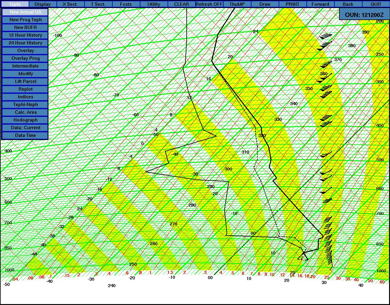
Instability is a catch-all term we use for a myriad of different things. This includes the buoyancy added by moisture, but since moisture is so all-important it gets a mention all to itself. I'm also talking about steep lapse rates, cold air aloft, and intense surface heating. All these things contribute to destabilizing the atmospheric column, making thunderstorms more likely to occur.
Check out this picture to see a layer of nearly dry adiabatic lapse rates aloft, from about 820 mb to 575 mb. This helps with destabilization because, if you have a cloud growing in this, the air rising in the cloud cools off more slowly with height than the environment around it; this makes the cloud even more buoyant.
link
Now, you can have all the instability in the world but if you don't start an air parcel going, the potential energy of convection is just that--potential. So you need some mechanism to get the air moving. This is where lift comes in. Lift can come in all sorts of forms. An extra-warm parcel of air can cause enough lift to start a thunderstorm. But usually we look for convergence along surface features--a dryline, a cold front, a warm front, a seabreeze, an outflow boundary. When you bring air together at ground level, it is forced up, so any convergence feature is a good lifting mechanism.
Finally, we have shear. There are two kinds of wind shear I want to talk about--directional shear and speed shear. Directional shear is where the wind direction changes with height. Speed shear is where the wind speed changes with height.
Speed shear is something we gauge usually from 0 to 6 km. We simply look at the vector difference between the surface wind and the wind at 6 km (usually represented by 500 mb). The more shear there is, the less likely the storm is to rain itself out, so it can be longer-lived.
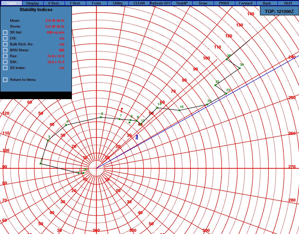
Directional shear is what we look at on hodographs. Directional shear allows for low-level vorticity (spinning) to occur, and when it's ingested into the thunderstorm updraft, it can help spin up a tornado.
Now, you can have speed and directional shear in combination--and that's best for tornadic thunderstorms.
Check out these two pictures from this morning. They show tremendous directional and speed shear.
link
link
So you look for moisture, instability, lift, and shear.
But how much?
Well, that's somewhat geography-dependent.
For example, "high" dewpoints in Winnipeg aren't the same as "high" dewpoints in Edmonton. For Winnipeg, usually 17 degrees Celsius or higher is needed to produce decent thunderstorms. In Edmonton, it seems anything over 10 is good. (Although for the Edmonton tornado of 1987, dewpoints were in the low 20s--good enough for storms pretty much anywhere.)
Instability also seems geography-dependent, but it's also situation-dependent and season-dependent. The main measure of instability we use is convective available potential energy, or CAPE. Storms with as little as 500 j/kg of CAPE can be supercells (if the shear is just right, and especially in the shoulder seasons), and storms with that little CAPE can do some amazing things in Alberta. Conversely, in Manitoba, we don't get too excited until CAPE goes over 1500 j/kg.
Lift isn't easy to measure. There are computer simulations that can do it, but that's beyond the scope of what I do on the desk every day. Suffice it to say that advancing cold air (cold front, outflow boundary, seabreeze) acts as the strongest lifting mechanism.
Shear is perhaps the most important storm type discriminator. Speed shears from 0-6 km of less than 30 knots usually do no more than give, at worst, multicells. The higher you go, the more supercells are likely. Usually once you get into 50 knot territory, you no longer even consider multicells. Of course, you can have too much shear, as well. I have seen storms try to get going, but the tops get sheard off and the clouds end up leaning over more than the Tower of Pisa. When this happens and no storms can form, we call these clouds "turkey towers" because they look like turkey necks, gobbling up into the sky. Kind of fitting, I think, because when you see turkey towers, the shear has gobbled up the storm potential.
Groan.
Forecasting thunderstorm severity, type, and even whether they'll happen at all is a challenge. It's so challenging that some of the top meteorologists in the United States have jobs devoted to doing just that.
I try my best at this forecasting game. Sometimes I win and sometimes I lose. But no matter what, I always learn.
posted by Dave "storm structure" Carlsen @ 4:07 AM
0 comments
![]()


0 Comments:
Post a Comment
<< Home