Let's get going!
So this morning and early this afternoon I'm planning to blog in 3 parts: first, with analyses showing how ingredients are now; second, with a model-based forecast for tomorrow; and third, with a model-based forecast based on the 12Z runs, including a convection-allowing model.
Here goes.
Moisture is nicely in place this morning, as this surface pressure and dewpoint chart shows:
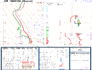
As well, a representative sounding of the airmass we'll be playing in for a couple of days is here, also showing plenty of low-level moisture:
Here's a sounding showing what the upstream winds look like:
So all of the ingredients are there and won't likely be moving anytime soon. In fact, as I'll show in my next blog post, model forecasts and the SPC outlook indicate a better than average chance for supercells in our region of interest on at least Friday and Saturday, with disagreement amongst the models after that.
As a side note, the 8 AM SPC outlook for today has a 5% tornado risk and a 30% hatched hail risk that necessarily extends into the Red River Valley. The warm front, as we can see from the temperature/dewpoint map above, is somewhere in North Dakota--favourable for a) low-level wind shear if storms go in the daytime, and b) favourable for severe nocturnal thunderstorms here in Winnipeg.
Too bad I can't chase today.


0 Comments:
Post a Comment
<< Home